
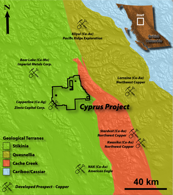
Cyprus Project
The road-accessible 61,880 hectare Cyprus Project is situated in north-central British Columbia, Canada. It includes the historical Kaza and Northstar copper prospects (see the Company's February 20, 2024 news releases for Option details) and is considered a district-scale copper-gold porphyry exploration Project.
Project Highlights:
- Historical drill intercepts include 0.55% copper over 138.3 metres
- Historical trench sampling includes 1.68% copper over 23.0 metres
- Over 1% copper and up to 5.1 gpt gold in historical soil sampling
- Two road-accessible copper-gold porphyry prospects (Kaza & Northstar) approximately 10 km apart
- A combined 6,573 metres of drilling in 69 drill holes
- District-scale exploration upside
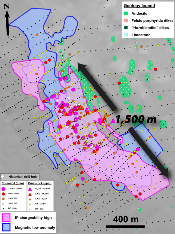
The Kaza Copper Gold Prospect
Extensive geochemical, geophysical and geological surveys, as well as historical drilling activities, have outlined a 2,000 metre by 600 metre footprint of high-level porphyry copper-gold mineralization and hydrothermal alteration. Highly anomalous copper-gold soil and rock geochemistry are spatially coincident with feldspar porphyry dikes, high IP chargeability and low magnetic response.
Historical soil samples up to 5.09 gpt gold and 10,000 ppm copper exist at the Kaza prospect. Surface chip samples from 1973 include 0.88% copper, 15.4 gpt gold and 120 gpt silver over 4.0 metres. Historical drill intercepts include 0.88% copper, 15.4 gpt gold and 127 gpt silver over 1.2 metres in drill hole 68-9.
The company believes historical operators did not drill test the Kaza prospect to sufficient depths with the deepest hole reaching only 195 metres vertical depth. The surface expression of the Kaza prospect is interpreted to be the upper reaches of a porphyry copper-gold system.
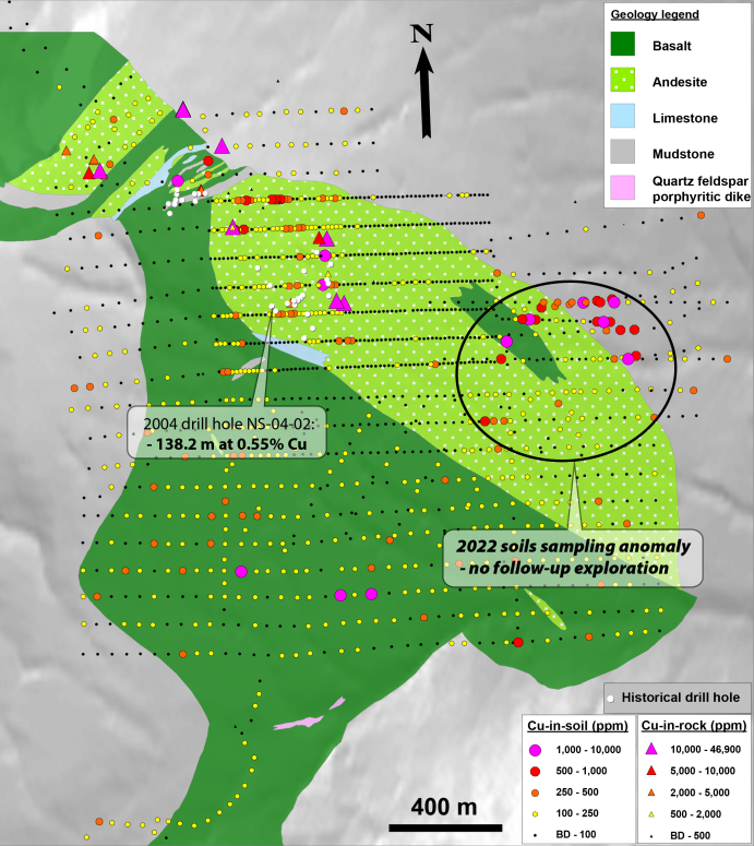
The Northstar Prospect
Two discrete mineralized areas on the Northstar claims have seen a combined 4,900 metres of drilling: the Main Zone and the B showing. Copper mineralization at the Main Zone consists of bornite and lesser chalcocite within faulted and fractured andesite. The B showing consists of several zones of vein and shear-hosted chalcocite and minor bornite hosted in andesitic volcanics, along with disseminated and fracture-filling chalcocite, bornite and chalcopyrite.
Excavation and channel sampling in 1997 at the B showing yielded 23.0 metres grading 2.1% copper in trench TN-1. Diamond drill hole NS-04-02, drilled in 2004 at the B showing, intersected disseminated and fracture-filling chalcocite, bornite and chalcopyrite mineralization which assayed 0.55% copper over 138.2 metres (Figure 3). Diamond drill hole 68-10, drilled in 1968 at the B showing by Northstar Copper Mines Ltd. intersected 1.68% copper across 14.6 metres with mineralization occurring as vein and shear-hosted chalcocite and bornite.
The Company believes the historically outlined zones of copper mineralization at the Northstar prospect are likely driven by a magmatic-hydrothermal system in the immediate vicinity, likely to the east and to depth of the mineralization encountered at the B showing.
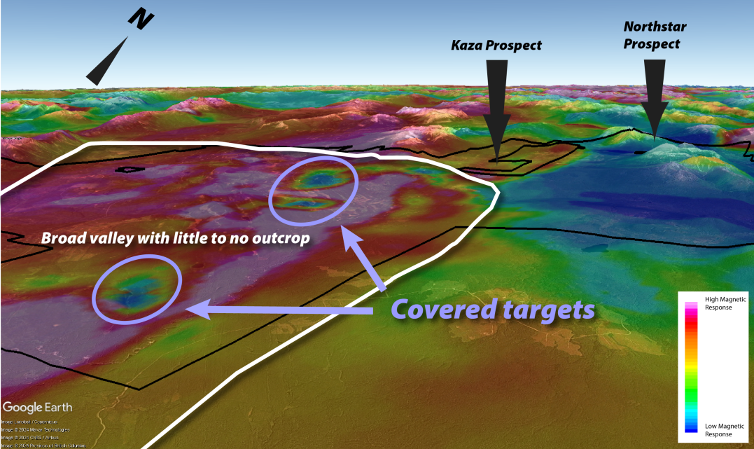
District-Scale Exploration Upside
A broad valley with very little outcrop exposure is situated to the southwest of the Kaza and Northstar prospects. The roughly 15 km wide valley is the manifestation of a series of northwest-trending faults which represents a district-scale exploration opportunity in the search for large copper-gold porphyry deposits. The valley is underlain by a complex and strong magnetic response related to long-lived intrusive activity in this portion of the volcano-plutonic arc. The Company is planning to commission a ZTEM survey covering 675 km2 that will outline targets in this covered and prospective portion of the Cyprus Project.
The historical results were completed by previous operators of the Kaza & Northstar Prospects. Although the Company was not involved in the original work in respect of these results, proper industry data verification procedures appear to have been followed.